Catch issues early
You can get your bearings faster by putting your location directly on the plan sheets and identifying issues that aren’t documented.
Clearly communicate work progress
Utilize location services to tag photos, improve communication and work progress, and give foremen a one-click solution to take a photo with the exact location included so anybody else with access to the project can view the information.
Reduce labor costs
Use the mobile app to easily locate where a foundation set will go on a site without hiring a survey crew and spending extra labor dollars.
See your equipment location
By integrating with HCSS Fleet Telematics, see the precise location of your equipment overlaid with the plan sheets, giving project context to the equipment location.
See what HCSS can do for you
Schedule a demo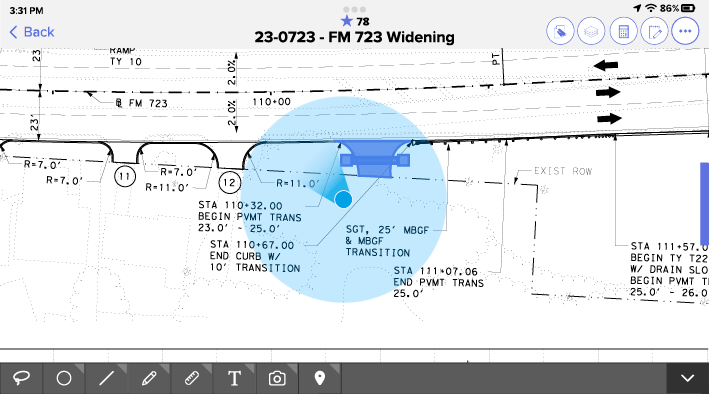
Ask our customers why they trust HeavyJob for construction site preparation


Just the layers location feature alone – this tool really is empowering people.
- Julia Salgueiro, Preston Companies

Utilizing HCSS software allows you to do away with printing out any paper and ensures your information is available to anyone.
- Tom Warner, Bay Cities Paving & Grading
91%
of Docs & Plans customers reduce rework
5
hours/month reduced travel time per PM
4.6/5
Apple App Store average rating
Build right the first time, every time
Step 1
Share your business headaches
After submitting a demo request form, an HCSS expert will follow up with you by the end of the next business day to discuss your business needs and requirements.
Step 2
See HCSS in action
Then, we’ll walk you through a demo tailored to specific HCSS solutions that can help solve your current business problems.
Step 3
Get up and running in days
Finally, you’ll be assigned a dedicated implementation specialist who will manage your implementation from start to finish and ensure project completion.
Frequently asked questions
What are site prep location services in construction?
Site prep location services refer to the digital integration of GPS and geolocation data within construction plan sets to guide earthmoving, clearing, and utility installation. In the heavy civil sector it transforms a static blueprint into a live, interactive map. By using the GPS in a mobile device, HCSS software shows workers exactly where they are standing on the project site relative to planned structures, utilities, and boundaries, ensuring that the work occurs in the right place.
How does HCSS software help with construction site preparation?
HCSS software streamlines site preparation by digitizing the “pre-dig” process. It allows teams to overlay complex infrastructure plans onto real-world coordinates. Before the first bucket hits the dirt, foremen can use HCSS to visualize clearing limits, staging areas, and excavation zones. By providing a centralized platform for all site data, it eliminates the need for bulky paper plans and ensures that every crew member is working from the most current site layout.
How do site prep location services reduce rework and costly mistakes?
Location services allow crews to verify locations before they dig, drill, or pour. By seeing their real-time position on a plan sheet, operators and foremen can avoid striking existing underground utilities or placing footings in the wrong coordinates. This proactive verification significantly reduces rework and prevents the catastrophic costs associated with utility hits and structural misalignments.
How do field crews use site prep location services on the jobsite?
On massive highway or bridge projects where traditional landmarks are scarce, field crews use HCSS location services to navigate the jobsite with survey-level confidence. A foreman can simply look at their tablet to see their physical position represented as a “blue dot” on the project plans. This allows them to quickly identify the start and end points of a run, find specific manholes, or mark clearing limits without having to wait for a survey crew to stake out every minor detail.
How do I ensure location accuracy on a construction plan sheet?
Accuracy is maintained through a process called plan calibration. Users align digital plans with real-world coordinates by selecting two or more known points on the jobsite (such as survey stakes or existing monuments). Once the software is calibrated to these GPS coordinates, the digital blueprint becomes geographically aware. This ensures that the “blue dot” on the screen matches the worker’s true physical position within a few meters, providing the reliable data needed for large-scale infrastructure work.
How do site prep location services support communication between the field and the office?
Location services bridge the communication gap. When a field crew encounters a site issue like an unexpected utility or a soil condition change, they can take a GPS-tagged photo or note. This data is instantly shared with the office, allowing engineers and project managers to see the exact location of the problem on the map. This instant, visual context speeds up the RFI process and ensures the office sees exactly what the field is experiencing.
What hardware is required to use HeavyJob Docs & Plans site prep and location features?
One of the greatest advantages of HCSS is the low barrier to entry. There is no need for expensive, specialized surveying hardware to get started. These site prep and location features are powered by the standard GPS chips found in everyday mobile devices, such as iPads, and iPhones. While HCSS can integrate with high-precision external GPS antennas for sub-centimeter accuracy, most contractors find that their existing fleet of mobile devices provides more than enough precision for general site navigation and documentation.
Didn’t get all of your questions answered?
Request info